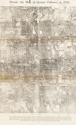
LHM003 Mosaic Air Map of Greater Oshawa in 1928
Description
- Media Type
- Image
- Item Type
- Maps
- Description
- "This composite picture of Greater Oshawa is made up of thirteen aerial photographs taken at a height of ten thousand feet. It has just been completed for the Government and is reproduced here for the first time by special permission of the Department of Militia and Defence. The reader will easily recognize familiar landmarks which will facilitate a ready reading of the map. Thus looking north, to the left in the middle distance, one may find Alexandra Park, with the gold course to the west. The Oshawa Creek and the Railways are conspicuous features." This picture was printed in The Oshawa Daily Times.
- Publisher
- The Oshawa Daily Times
- Date of Original
- August 11, 1928
- Dimensions
-
Width: 12.8 in
Height: 22.4 in
- Local identifier
- LHM003
- Language of Item
- English
- Creative Commons licence
 [more details]
- Copyright Statement
- Copyright status unknown. Responsibility for determining the copyright status and any use rests exclusively with the user.
- Location of Original
- Map Drawer 1
- Terms of Use
- please credit Oshawa Public Libraries, Local History Collection
- Contact
- Oshawa Public LibrariesEmail:nadams@oshawalibrary.on.ca
Website:
Agency street/mail address:
Nicole Adams, Local History and Genealogy Librarian
65 Bagot Street
Oshawa, ON L1H 1N2
905-579-6111 EXT 5253


