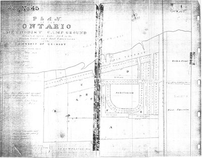
Plan of Ontario Methodist Camp Ground, 1875: Auditorium Circle and Victoria Terrace
Description
- Creator
- DeCew, Edmund, Esq P.L.S., Surveyor
- Media Type
- Image
- Text
- Item Types
- Measured drawings
- Maps
- Description
- This is the plan for the Ontario Methodist Camp Ground in 1875. This was the first year that the Ontario Methodist Camp Ground owned the land sold to them by John B. Bowslaugh, which was approximately 12 1/2 acres. This map lays out the plots of land the company wanted to lease. They are clustered around the auditorium circle, to the east of auditorium circle, along Victoria Terrace and extending west along the lakeshore. Lake Ontario is to the north and John B. Bowslaugh's land is to the south. The size and space for approximately 125 plots are noted as are reserved lands for public use.
- Inscriptions
- Plan of the Ontario Methodist Camp Ground, Situated upon Lots No. 3 in the Broken Front and the First Concession of the Township of Grimsby
- Date of Original
- May 20th, 1875
- Dimensions
-
Width: 75 cm
Height: 59.4 cm
- Image Dimensions
-
Image Width: 75cm
Image Height: 59.4cm
- Map Scale
- Fifty feet to 1 inch
- Subject(s)
- Personal Name(s)
- DeCew, Edmund, Esq. Provincial Land Surveyor (1812-1892)
- Local identifier
- 2007-282-02-07
- Geographic Coverage
-
-
Ontario, Canada
Latitude: 43.1942909202624 Longitude: -79.5251852380371
-
- Donor
- Grimsby Historical Society Archives
- Copyright Statement
- Public domain: Copyright has expired according to Canadian law. No restrictions on use.
- Location of Original
- Grimsby Historical Society Archives
- Contact
- Grimsby ChautauquaEmail:gen-library@grimsby.ca
Website:
Agency street/mail address:18 Carnegie Lane
Grimsby, ON L3M 1Y1
905.945.5142


