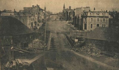
Beckwith Street, Smiths Falls, circa 1885
Description
- Media Type
- Image
- Newspaper
- Item Type
- Newspaper clippings
- Description
- Historic photo published in Record News 11 January 1973 - the caption reads: "A few weeks ago we published a photograph of Beckwith Street on "Turkey Day," when farmers came to town to sell their goods in the street. This photograph, provided by S. Wood, gives a better view of main street in the late 1800s. In the near right is the old sawmill, and behind that is the Molson Bank. On the left side of the street is Garrett's Bakery, and in the background are the twin spires of the churches, and the fire hall tower, just recently lowered. ..."
(Newspaper caption cropped out). - Notes
- This image was also published in "A history of the Smiths Falls Lock Stations, 1827-1978" by Peter DeLottinville, Vol. II, 402-3, fig.22. The caption reads: Beckwith Street looking north, ca. 1885? Saw mill on right and grist mill on left belonging to Ward family. The wooden bridge in this photo was later replaced by a stone bridge which still stands (Collection of G.R. Davis, Smiths Falls).
It was also published in Glenn J. Lockwood's "Smiths Falls: A Social History of the Men and Women in a Rideau Canal Community 1794-1994." Smiths Falls: Corporation of the Town of Smiths Falls, 1994, p.145, pl. 68 "... Beckwith street from Ward Island as photographed circa 1885. These views were shaped and framed by the decisions of Abel Russel Ward and William Simpson half a century earlier in the early 1830s. ... The circa 1885 view shows Ward's grist mill, commonly known as "the old red mill" on the left, with his (later J.B. Lyle's) sawmill across the road from it on the right. The church spires framing the upper vista of Beckwith street are a visual reminder of how effectively Simpson's gifts of sites for churches contributed to make Smith's Falls a major regional centre of the Rideau Canal. Signs at either side of the 1849 timber crib bridge warned farmers coming into the village to drive their horses at a slow pace to keep wear on the bridge to a minimum." - Subject(s)
- Geographic Coverage
-
-
Ontario, Canada
Latitude: 44.90011 Longitude: -76.01607
-
- Copyright Statement
- Copyright status unknown. Responsibility for determining the copyright status and any use rests exclusively with the user.
- Contact
- Smiths Falls Public LibraryEmail:info@smithsfallslibrary.ca
Website:
Agency street/mail address:81 Beckwith Street North
Smiths Falls, ON K7A 2B9
Phone number: 613-283-2911


